


Join Us
Join Us

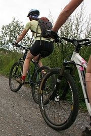
The dyke trails are very popular destinations for various activities like walking, jogging, hiking, biking, birdwatching, picnicking and sightseeing. Some of the trails connect while others are singular routes connected by side streets.
Some trails are boardwalk while most are covered with gravel or they are paved. Many of the dyke trails in the region are flat, level and easy going routes. Most of the routes are suitable for all ages and fitness levels. Most are wheelchair and baby stroller friendly.
Along most of the routes are sightseeing benches, green space parks, picnic day use areas, waterfront access and parking lots. Many of the routes include many different trail access points via side streets.
The West Dyke Trail is one of the many dyke trails in the region. Some of the other notable dyke paths include the Sea Island Trails, South Dyke Trail, Steveston Greenway and Middle Arm Trail.
West Dyke Trail : The trail is a 5.5 kilometre gravel path following the Sturgeon Banks. The route connects Garry Point Park with the Terra Nova Park and Nature Area. Along the route you pass by marshes, houses and a golf course. There are views of mountains, the ocean and the Gulf Islands. Best access is in Garry Point Park and Terra Nova Park.
Steveston Greenways : The greenway path consists of side roads, a 1 kilometre wooden pier on stilts, paved and gravel pathways. The greenway route follows the south arm of the Fraser River and connects to historic sites (Gulf of Georgia Cannery and Britannia Heritage Shipyard), Garry Point Park, Imperial Landing Park, fishing pier, beaches, patio restaurants, fine dining, gift stores and industrial businesses. Accessed best from Garry Point Park and London's Landing.
South Dyke Trail : The trail route follows the south arm of the Fraser River and connects to Gilbert Beach, Fishing Pier, off leash dog park, Finn Slough, Horseshoe Slough and Shell Road Trails. Enjoy views of Mt. Baker, historic sites, sandy beach and historic slough settlements. Accessed best from Gilbert Beach.
Middle Arm Trail : The trail is a 5.5 kilometre path following the middle arm of the Fraser River. The route connects to Hollybridge (picnic park and waterfall), Community Garden (garden for local residents for planting) and Dover Beach (sightseeing platform of Swishwash Island). There are views of North Shore Mountains, Fraser River, Vancouver International Airport and Sea Island. Accessed best from Terra Nova Park and Hollybridge.
Sea Island Trail : The trail follows the shores of Sea Island, home to the International Vancouver Airport. The route connects to Flight Path Park (aviation sightseeing), McDonald Beach Park (picnic park) and the Iona Beach Regional Park (sandy beaches). Accessed best from McDonald Beach Park and Iona Park.
Address:
