
Entries with Name of Places starting with 'S'
Spruce Fringe Trail - Pacific Rim National Park Reserve

Spruce Fringe Trail is an easy-going hiking trail located in the Pacific Rim National Park connecting visitors to Combers Beach. The trail is an up and down pathway located near the Villages of Tofino and Ucluelet, Vancouver Island, British Columbia, Canada.
Read morePacific Rim Highway
Tofino, Ucluelet
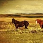
Spruce Woods Provincial Heritage Park

The park is a main destination in the summer for activities like hiking, backpacking, mountain biking, horseback riding, camping, canoeing, kayaking, birdwatching, swimming and picnicking. During the winter months the park is popular for snowmobiling and cross country skiing.
Read moreHwy #5
Brandon
Squamish Estuary Trails

The Squamish Estuary Walking Trails explore the mudflats, marshes, wetlands, tidal channels, rivers, meadows and forests in the backyard of Squamish Village. The trail starts along a dyke following Cattermole Creek. The brush shouldering the path is sometimes almost 10 feet tall and ...
Read moreVancouver Street
Squamish
SS Klondike Historic Site

The SS Klondike was part of a fleet of 250 riverboats that once explored the mighty Yukon River and the surrounding chain of lakes and rivers.
Read moreWhitehorse
SS Moyie National Historic Site, Kaslo

The SS Moyie is recognized as a National Historic Site and a BC Landmark. The well maintained and restored paddle wheeler is a historic museum. Inside are displays of pictures, artifacts and models depicting the history of the early 1900s living life on Kootenay Lake.
Read moreFront Street
Kaslo
SS Sicamous

SS Sicamous was the last and the biggest ever passenger boat built by the Canadian Pacific Railway to service the communities of the Okanagan Valley. The 228 foot passenger boat transported trappers, miners and forestry workers.
Read morePenticton
St. Ambroise Beach Provincial Park

The white sandy beach is the highlight of the park. The beach is the central hub of activity in the park for swimming, sunbathing, reading, sightseeing and birdwatching. Other activities enjoyed throughout the park include camping, hiking, sightseeing, picnicking, windsurfing and fishing.
Read moreSaint Ambroise
St. Mary Lake

St. Mary Lake is popular for fishing, canoeing, swimming and birdwatching. The roads and mountains around St. Mary Lake are popular for hiking, cycling, mountain biking and hiking. The St Mary River enters and exits the lake. The exit river is a good put- in point for rafting.
Read moreKimberley
St. Mary Lake

St. Mary's Lake is on the northern end of Salt Spring Island, BC is popular for canoeing, kayaking, boating, birdwatching, picnicking, sightseeing and swimming.
Read moreLang Road
St. Mary Spring Trail

The St. Mary Spring Trail near Skidegate BC is a short single track climb up the side of a hill to some views of Hecate Strait.The significance of the trail is the drinking fountain, the Madonna wooden carving and the legendary words.
Read morehaida gwaii
St. Mary's Island and the Attikamek Trail

St. Mary's Island is a hiking and sightseeing destination located in Whitefish Channel on the St. Mary's River in the community of Sault Ste. Marie, Ontario, Canada. Sault Ste. Marie is located in Algoma Country in Northern Ontario.
Read moreCanal Drive
Sault Ste Marie
St. Mary's River Boardwalk

St. Mary's River Boardwalk is a sightseeing walkway following the banks of the St. Mary's River located on the waterfront in the community of Sault Ste. Marie, Ontario, Canada. Sault Ste. Marie is located in Algoma Country in Northern Ontario.
Read moreBrock Street
Sault Ste Marie
St. Victor Petroglyph Provincial Park
.jpg "sign prov")
Largest collection of petroglyphs on the Canadian plains and one of five sites in Canada where petroglyphs are found on horizontal rock surfaces.
Read moreMain Street and Lalonde Avenue
St. Victor
Influencer:
Stafford Lake

The pathway is paved and loops around the lake. Along the edges of the trail are various sitting benches ideal for sightseeing and birdwatching.
Read moreBrooks
Stake Lake

Stake Lake is a wilderness recreation destination located southwest of Kamloops , British Columbia, Canada. It is a popular spot for hiking, mountain biking, fishing and nordic skiing. Although, it is important to note that the Stake Lake region is designed to cater to the nordic skiing crowds dur
Read moreLac Le Jeune Road
Kamloops
Stamp Falls Provincial Park

Stamp Falls Park is a waterfall educational park located near the community of Port Alberni, BC on Vancouver Island, Canada. The forested park is 327 hectares in size and home to a cascading waterfall and a popular Salmon spawning river. Popular for the salmon that is
Read moreBeaver Creek Road
Port Alberni
Stanley Park

The park measures over 400+ hectares (1000+ acres) and it is the most visited park in the Metro Vancouver region (Greater Vancouver Regional District). The park includes a network of wooded trails (27 kilometres), the Seawall (8.8 kilometre waterfront pathway), swimming beaches (2), forest groves...
Read moreBeach Avenue
Vancouver
Star Lake - Gold River

Star Lake is located near the community of Gold River, BC on Vancouver Island, Canada. The small lake is a recreation destination situated in the back country forests south of the community.
Read moreGold River
Star Trek Station

The Star Trek Station was built to look like and provide the feeling of being on the planet Vulcan. Some even say the Space Station arrived from the night sky landing permanently in the community of Vulcan.
Read moreVulcan
Stawamus Chief

The Stawamus Chief is a popular natural attraction that dominates the skyline in Squamish, BC, Canada. The Chief is over 702 metres (2303 Feet) tall and is the second largest free standing granite outcropping in the world - second to only the Rock of Gibraltar.
Read moreLogger's Lane
Squamish