Burnaby Mountain

Difficulty: Easy - Family
Park Amenities:
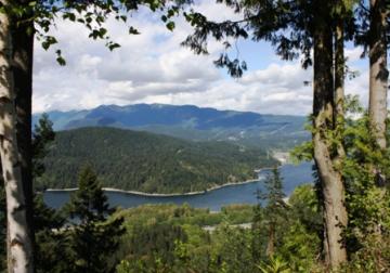
Burnaby Mountain is one of the dominant geographical features of the community of Burnaby, BC. The mountain peak reaches an elevation of 370 metres (1214 ft) and looks out over Burrard Inlet and the City of Vancouver.
Burnaby Mountain Conservation Area is located on Burnaby Mountain. The mountain is a recreational destination open to the public and it is also home to Simon Fraser University, a restaurant and some municipal buildings.
Much of Burnaby Mountain is covered in lush, thick and rugged west coast forest with numerous streams and creeks. A section of the mountain is reserved for recreation use. Another larger section of the mountain is a protected conservation area. And in the centre of the park is the university grounds and facilities.
Throughout the Burnaby Mountain Conservation Area are many recreation trails, facilities and buildings. Some of the structures and attractions in the park include a rose garden, totem poles, a restaurant, viewpoints, washrooms, playgrounds, a pavilion, day use picnic sites, bike park, lookout points and sculptures.
The totem pole sculptures represent the relationship with the local First Nation people. The Japanese sculptures were created by Nuburi Tokyo and his son and they celebrate the relationship of the City of Burnaby with Kushiro, Japan.
The recreational side of the mountain is layered with many trails and pathways. The recreation routes are widely used for activities like hiking, jogging and mountain biking. One area is reserved for horseback riding.
In total there are over 22 trails on the mountain measuring 23 kilometres. Many are shared trails. Some are specific to hiking or mountain biking. The biking trails are developed at various degrees of difficulty with drops, jumps and downhill runs.
Trails range from easy going (level) to moderately difficult (mountainous slopes). Beginner trails follow wide gravel paths with little elevation gain. Intermediate trails are narrow gravel trails with steeper grades and exposed tree trunks and boulders. Difficult trails are narrow gravel trails with slippery sections, steep climbs, stairs with many steps, blind sections and exposed tree roots.
Most of the trails are well marked. At many of the junctions and trailheads are information signs and trail maps indicating the usage, degree of difficulty and distances. Some of the more unique trail names on the mountain include Hang Your Hat, Gnomes Homes, Cardiac Hill, Jim's Jungle and Gear Jammer.
Explore Burnaby Mountain in Burnaby, BC, Canada
Address:
How To Get ToBurnaby Mountain
:There are parking lots and park entrances located on the perimeter roads circling the park. The east entrance parking lots are located on North Road. The south entrance is located on Garibaldi Way. The west entrance is located on Centennial Way & Ridgeview Drive (just off Hastings Street). The north entrance to the park is on Barnett Highway.


