Cascade Highway High Altitude Adventure Destination

Cascade Highway Road Trip
There are so many backroad highways in Canada to explore. Some are paved, well known and heavily traveled while others are gravel, pot-holed and considered local secrets which – for tourists – require a “Sherlock Holmes” type attitude to discover. That is where we come in as we have traveled and explored every highway in Canada.
One such backroad highway in Canada is the Cascade Highway which explores the Monashee Mountain Range. The scenic highway goes by many names such as the Old Cascade Highway, Santa Rosa Road and the Old Cascade-Rossland Highway.
The highway road measures approximately 72 kilometres and is divided into three sections – the Cascade side, the middle and the Santa Rosa side. The highway connects the Okanagan Valley with the Kootenay region in British Columbia, Canada.

Switchbacks on Cascade Highway
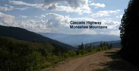
The, rough and rugged, gravel Cascade Highway is a wilderness and sightseeing travel experience which takes you deep into the forests while exploring high mountain ridges and peaks. The route is a “back door” highway connecting the communities of Christina Lake (southeast of Osoyoos) and Rossland, British Columbia, Canada.
The mountain pass does not disappoint as it is an eye full of mountain scenery and snow capped peaks. On our last exploration over the mountain pass we did not come across many vehicles. In fact, we bumped into more mountain bikers and ATVs than we did vehicles.
During the winter months the highway is closed on many occasions as it is considered too narrow and dangerous for vehicles. However, during the snow months the highway becomes a popular snowmobile route.

Views from Cascade Highway
The gravel road is well known for wildlife sightings like bear, deer and cougar. On this last trip we photographed birds in flight like eagles and birds of song like the chestnut-backed chickadee, spotted towhee and dark-eyed juncos. The birds and the natural far-reaching scenery was plenty to keep us entertained.
Along the backcountry highway route are some wilderness trails. Most are shared trails suitable for hiking, backpacking, mountain biking and horseback riding. Two of our favorite trails on the route are the 7 Summits Trail and the Dewdney Trail. Both are wilderness trails. Both are under rated. Both will not disappoint.
Just down the road from the trailhead of the 7 Summits Trail we met a group of mountain bikers gearing up for a downhill ride on the Record Ridge Trail. It is a rough and tumble downhill trek starting from peaks and descending down to the community of Patterson, which is between Rossland and the US border.
There are no services on this highway. Be prepared and always drive with a spare tire and water. Weather and temperature can change quickly in the mountains. There are a few sections along the gravel highway which are really rough and some say 4×4 only which is what we were driving.
And remember… bring a camera because it will provide you with memorable moments.


Good eye. Thank you for pointing it out. The article was from 2012 and we have corrected it. Feel free to join our website and contribute articles for our communities for free. Everything you contribute we will credit to you. We operate the largest #SocialTravel interactive website in Canada. Love to have your expertise contributing content.
The Record Ridge trail doesn't end anywhere near Christina lake – which is over 70km away. If coming down the shortest side (Dewdney) you pop out in the community of Patterson, which is between Rossland and the US border.