Kluane National Park & Reserve, Haines Junction, Yukon Territory, Canada
Sheep Mountain
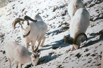
Sheep Mountain is a popular recreation destination in the Kluane National Park and Reserve located near the community of Haines Junction, Yukon Territories, Canada. The mountain is home to a few of the longer backpacking adventures and day hikes located in the park. It is also an area in the park that is highly recommended for Dall Sheep wildlife sightings.
The local First Nation people of the region refer to Sheep Mountain as Tachal Dhal. Today at the base of Sheep Mountain, on the shores of Kluane Lake (Yukon's largest lake), is the Tachal Dhal Visitor Centre which is Canada Parks Office. The centre is a good place to stop prior to any adventure so to retrieve update reports on the conditions of the trails.
There is a good selection of quality hiking trails and hiking routes on Sheep Mountain. Some of the trails include the Soldiers Summit (1 kilometre/0.6 miles), Sheep Mountain Ridge (11 kilometre/7 miles), Sheep Creek (10 kilometre/6 miles), Bullion Plateau (24 kilometre/15 miles), Slims West (45 kilometre/27.4 miles), Observation Mountain (19 kilometre/12 miles) and Slims East Trails (46 kilometre/28 miles).
The Sheep Creek Trail is one of the more popular day hikes exploring the mountain. The trailhead entrance is located 2 kilometres down the highway from the Tachal Dhal Visitor Centre where there is an exit accessing an old gravel road. Follow the gravel road to a parking lot. In the trailhead parking lot are pit toilets, picnic tables, information signs and a trail map.
Sheep Creek Trail is a 10 kilometre ( 6 mi ) return hiking route with an elevation gain of about 430 metres (1400 feet) reaching an elevation of 1281 metres (4200 feet). The route is challenging, uphill and considered difficult. Hikers have been timed between 4 to 7 hours to complete the route.
The Sheep Creek Trail begins by exploring through forest and around rock clefts for 2 hours before reaching a viewing platform. The trail continues for another 3.7 kilometres following an old mining wagon road which leads to a junction. Here, at the junction, a left leads you down to Sheep Creek and a right leads you up into the sub alpine ridges to a natural viewpoint over looking the Slims River Valley region.
Further up the main gravel access road are even more hikes but these trails are multi-day, long haul, backpacking and horseback riding adventure routes which require wilderness camping.
The Slims West Trail is 45 kilometres long (27.4 miles) and the Slims East Trail is 46 kilometres long (28 miles). Both take 2-5 days to complete on foot. However.. the Slims East Route is more challenging as it has an elevation gain of 910 metres (3000 feet) compared to 97 metres (318 feet) on the Slims West Trail.
Sheep Mountain in the Kluane National Park & Reserve, Yukon Territories, Canada near Haines Junction , Yukon
Sheep Mountain is a popular recreation destination in the Kluane National Park and Reserve located near the community of Haines Junction, Yukon Territories, Canada. The mountain is home to a few of the longer backpacking adventures and day hikes located in the park. It is also an area in the park that is highly recommended for Dall Sheep wildlife sightings. </span></p>
<p>The local First Nation people of the region refer to Sheep Mountain as Tachal Dhal. Today at the base of Sheep Mountain, on the shores of Kluane Lake (Yukon's largest lake), is the Tachal Dhal Visitor Centre which is Canada Parks Office. The centre is a good place to stop prior to any adventure so to retrieve update reports on the conditions of the trails. </p>
<p>There is a good selection of quality hiking trails and hiking routes on Sheep Mountain. Some of the trails include the Soldiers Summit (1 kilometre/0.6 miles), Sheep Mountain Ridge (11 kilometre/7 miles), Sheep Creek (10 kilometre/6 miles), Bullion Plateau (24 kilometre/15 miles), Slims West (45 kilometre/27.4 miles), Observation Mountain (19 kilometre/12 miles) and Slims East Trails (46 kilometre/28 miles). </p>
<p>The Sheep Creek Trail is one of the more popular day hikes exploring the mountain. There are valley and mountain views and opportunities for wildlife sightings. During the summer months Dall Sheep visit the lower elevations of Sheep Mountain to feed.</p>
<p>The trailhead entrance to the Sheep Creek Trail is located 2 kilometres down the highway from the Tachal Dhal Visitor Centre where there is an exit accessing an old gravel road. Follow the gravel road to a parking lot. In the trailhead parking lot are pit toilets, picnic tables, information signs and a trail map. </p>
<p>At the end of the gravel parking lot is a gated access road. This road leads to the trailhead entrance of the Sheep Creek Trail. The same gravel road leading to the trailhead of the Sheep Creek Trail leads to the the trailheads of many other adventures.</p>
<p>Sheep Creek Trail is a 10 kilometre ( 6 mi ) return hiking route with an elevation gain of about 430 metres (1400 feet) reaching an elevation of 1281 metres (4200 feet). The route is challenging, uphill and considered difficult. Hikers have been timed between 4 to 7 hours to complete the route. </p>
<p>The Sheep Creek Trail begins by exploring through forest and around rock clefts for 2 hours before reaching a viewing platform. The trail continues for another 3.7 kilometres following an old mining wagon road which leads to a junction. Here, at the junction, a left leads you down to Sheep Creek and a right leads you up into the sub alpine ridges to a natural viewpoint over looking the Slims River Valley region.</p>
<p>Another long day hike in the area is the Bullion Plateau Trail. It is considered a challenging hike measuring 24 kilometres with an elevation gain of 885 metres (2900 feet). It takes about 6-10 hours to complete depending on the fitness levels of the group. </p>
<p>Further up the main gravel access road are even more hikes but these trails are multi-day, long haul, backpacking and horseback riding adventure routes which require wilderness camping. </p>
<p>The Slims West Trail is 45 kilometres long (27.4 miles) and the Slims East Trail is 46 kilometres long (28 miles). Both take 2-5 days to complete on foot. However.. the Slims East Route is more challenging as it has an elevation gain of 910 metres (3000 feet) compared to 97 metres (318 feet) on the Slims West Trail. </p>
<p>The wilderness country around Sheep Mountain is full of wildlife especially Dall Sheep and bears. Slims west and east are well known to be populated with bears and at times bear activity is high enough that the trail may be temporarily closed. Always check your weather and trail conditions prior to your departure.</p>
<p>And for your own comfort, when exploring in the Yukon wilderness, always carry mosquito repellant.</p>
<p>Sheep Mountain in the Kluane National Park & Reserve, Yukon Territories, Canada near Haines Junction , Yukon