Rossalnd
British Columbia
Canada
Trail Length: 43 kilometresDifficulty: ExtremePark Amenities:
Dewdney Trail connects the village of Hope with Fort Steele near Cranbrook, BC. However, we will be discussing the 43 kilometre section of the Dewdney Trail located between Rossland, BC and Christina Lake. This section of the trail explores two mountain summits and is also part of the TCT (Trans Canada Trail).
In total the Dewdney Trail is a 720 kilometres (447 miles) long. This historic and challenging trail explores rugged forests, navigates mountain summits and drops down into deep river valleys. The trail follows the 49th Parallel and the Canada-US Border and, during the mid to late 1800s, was a major transportation route servicing southwestern British Columbia, Canada trappers, miners and new settlers.
The historic pack trail is a popular route for mountain biking, hiking, backpacking, wilderness camping, sightseeing and horseback riding. Although, not all sections of the trail are bike and horse friendly. In these cases, mountain bikers and horseback riders are advised to take the alternate route along the Cascade Highway.
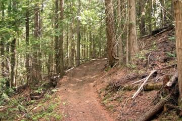
The Rossland-Christina Lake section of the trail is rough, and is considered a difficult route with numerous elevation changes as it climbs the Santa Rosa and Cascade Mountain Summits. The trail is, mostly, a single track trail connecting up with the Cascade Highway at various points along the route.
The west end of the Dewdney Trail, located near Christina Lake, BC, starts from the Santa Rosa Road. This 26 kilometre (16 mi.) section is a mixture of gravel road and single track trail leading down to the Trout Creek Recreation Site and then up to the Santa Rosa Summit and another campsite - the Santa Rosa Recreation Site. These are self maintained wilderness campsites - pack out what you pack in - leave no trace behind.
The east side of the Rossland-Christina Lake section of the Dewdney Trail is approximately 17 kilometres (10.5 mi.) long. The trail follows a gravel road and single track trail leading to the Cascade Summit. The last section of the trail starts from the Cascade Highway and drops quickly, over 700 metres, back down to Highway #22, just north of the Canada-US Border near Paterson, BC. This section of the trail is known as the Dewdney Drop.
The 5.4 kilometre Dewdney Drop is a section of the trail that mountain bikers enjoy allot as a short day ride. The challenging downhill section is easily accessed from the Cascade Highway west of Rossland, BC. Travel 11 - 12 kilometres on the gravel highway and on your left look for the trailhead marker and access to the Dewdney Drop.
Dewdney Trail, Rossland, British Columbia, Canada
Address:
Dewdney Trail, Rossland
Cascade Highway
Rossalnd
Canada
How To Get ToDewdney Trail, Rossland
:
How to Get Here: Travel to the community of Rossland, BC & access the Cascade Highway. At the Santa Rosa Summit look carefully on your right for the brown trailhead sign in the trees. Coming from the other end at Christina Lake continue traveling on Hwy #3 to Santa Rosa Road ( Cascade Hwy). Turn onto Santa Rosa and travel for 23.5 kilometres. There should be a cattle guard and large pull out gravel area. The trailhead is on your left.
No reviews yet for Dewdney Trail, Rossland.