
Join Us
Join Us


Lake Superior National Marine Conservation Area (L.S.N.M.C.A.) is a protected area measuring over 10, 000 square kilometres of lake, islands, shoals and shoreline.
The Lake Superior National Marine Conservation Area is currently the largest freshwater protected area in the country and throughout the world. It is also home to the largest freshwater fish breeding in Canada called the lake sturgeon and the site of 6 lighthouses.
The marine conservation area covers a large tract of land and water on the northern shoreline of Lake Superior. The area stretches 140 kilometres west to east from Bottle Point near Thunder Bay, Ontario to Thunder Cape and the Sibley Peninsula... and to the south of the lake is the Canada/U.S.A. boarder and the Isle Royale National Park.
The National Marine Conservation Areas Act (NMCAA) was created in Canada to protect sensitive eco systems from ocean dumping, undersea mining, oil and gas exploration.
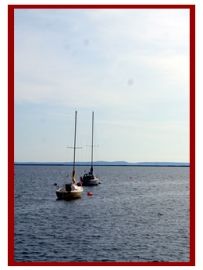
The shoreline, islands, bays, coves and lake waters of the Lake Superior National Marine Conservation Area are a popular destination for sightseeing marine wildlife and birds, as well as, enjoy activities like kayaking, sailing, boating, scuba diving and lighthouse sightseeing.
There are six lighthouses in the Lake Superior National Marine Conservation Area. They are located on Trowbridge Island, Porphyry Point, Shaganash Island, Slate Island, Battle Island and Lamb Island.
However, prior to the lighthouse, there were many shipwrecks. The lakebed of the conservation area is home to a graveyard of ships like the Gunilda and Fitzgerald. The Gunilda, built in 1897, sank off McGarvey Shoal on Lake Superior in 1911. Divers say the Gunilda is one of the best preserved underwater shipwrecks in Canada.
From some of the marinas on the shoreline of the conservation area are boat launches for self guided tours and charter companies providing sightseeing tours. Marine touring provides an opportunity for wildlife sightings like caribou, moose, great blue herons, pelicans, loons, peregrine falcons and bald eagles.
While sightseeing look closely at the exposed rock cliffs for First Nation pictographs and archaeological sites. The Anishinabek First Nation people have been around for a long time in this area and to them the lake is called, "Gitchi Gumme" meaning "The Big Lake".
Address:
