Water “Falling” in Nova Scotia, Canada
There are allot of “ings” on Cape Breton Island in Nova Scotia, Canada like canoeing, kayaking, hiking, cycling, mountain biking, backpacking, off roading, skiing, snowboarding, surfing, fishing and whale watching. But have you ever gone “falling”? That is the term I like to use when searching out waterfall adventures. It is not good English but it is slang in my adventure world.

EH Tourism at Egypt Falls
On Cape Breton Island there are some great waterfalls… some easy access and some require effort to view and enjoy. Recently, during my research missions on the island I treated myself to some great “falling” adventures. Recently I added two more to my Canadian waterfall list – the Egypt Falls and Ulsge Falls.
Not knowing much about the two falls I was excited about the surprises that lay ahead. However… I did find out the hiking distances to the falls and the trailhead locations of each fall. It was not an easy task either as information was limited. They do not make it easy to enjoy the region sometimes.
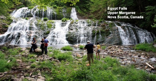
The Egypt Falls was the first of the two falls I explored. The falls are located in the Upper Margeree region of Cape Breton Island near Scotsville on Ainslie Lake. The main road accessing the gravel road entrance to the falls is Highway #395 North.
At first I had some difficulty finding the gravel access road.. mainly because I followed my instructions too closely… I over compensated per say. After going up the wrong road for some distance I turned around and back-tracked. Putting 2 and 2 together I finally figured out that the gravel access road was two bridges further up the main road and… guess what… there was a sign too… an “ugh” moment.
Traveling the gravel road I followed the small signs pointing to the trailhead. If it were not for the parked cars on the side of the road I might of missed the entrance too. Marking the trailhead entrance was a small printed sign on white paper wrapped in plastic half hidden in the bushes.

Tree Root Steps on Egypt Falls Trail
From the trailhead to the falls the hiking trail measures about 1 kilometre in and 1 kilometre out – 2 kilometres return. The distance is a rough guesstimate as the local people had no idea what the official distance of the trail was. In fact no one had ever hiked to the falls that I talked to. Knowing what I know now they are missing out big time because the falls were beautiful and the experience exhilarating.
From the trailhead the route follows a steep downhill path under a thick canopy of trees. Much of the path was decorated with an excessive high number of exposed tree roots and boulders. There were tree roots creating stairwells and some roots creating stumbling blocks. Being in the shade of trees, the route can be damp at times and is a natural breeding ground for mosquitoes. Spray well.
The trail, although well used, requires allot of high stepping, trail awareness and very good foot work as falling down would be like sliding down a waterslide. This is particularly important for the last 250 metres of the trail. To my delight the last part of the trail follows some switchbacks down a rock wall before dropping you into a canyon. To assist in the steep descent into the canyon the trail is lined with climbing rope hand rails. The path is narrow, the path is covered with loose dirt and it was a total hoot.

Egypt Falls on Cape Breton Island
During the descent to the falls there was one thought which kept bouncing around in my head and that was, “what goes down, must come up.” This was particularly loud when passing some of the people on the steep trail. Shaking my head… I saw people hiking in sandals, some were hiking with lap dogs, some with small children and some looking like they bit off more than they could chew and the climb back up was going to be very difficult for them.
Egypt Falls did not disappoint in the least. The cascading falls is a wide waterfall not a river chute falls. The spilling whitewater spilled over from one side of the river to the other. The falls are considered a wilderness fall with no development therefore boulders are used for sitting and snacking not picnic tables. For the adventurous there are more ropes for those who wish to climb to the middle of the falls.
I found the Egypt Falls Trail as much fun as the prize at the end of the trail – the waterfall. I found the trail a thrill ride on the way down and a challenging work out on the way up. I am bias though as I am a hiking and backpacking fanatic. Anytime nature challenges me it gets my motor running. My experience in the outdoors tells me that any adventure which leaves a permanent smile and pages full of photo album memories is a good adventure.

Ulsge Falls
The burning sensation in my legs soon numbed out and disappeared during my drive to the next “falling” adventure – Ulsge Falls. The falls are located in the wilderness regions in the backcountry of Baddeck, Nova Scotia. The main road to the falls is the paved road leading to the local golf course and Baddeck Forks. From the main road follow the signs to the 4 kilometre gravel access road which leads to the Ulsge Picnic Park and trailhead.
The park provides a picnic area and pit toilets in the large gravel parking lot next to the trailhead. The parking lot was busy with many cars on my visit.
The trail to the waterfalls is very family friendly. Most of the route follows a double wide 3 kilometre return trail through a forest of trees and along the banks of a small creek. The route is a dirt trail, very level and considered easy going with a few sections of exposed tree roots and boulders. Along the route, especially as you get closer to the falls, the boulders get bigger and the forest demographic transforms. Now… there are towering trees growing out of giant boulders with the tree roots wrapped around them like a head lock from a professional wrestler.

Boulder Tree on Ulsge Falls Trail
At the falls there were many people scattered around sitting on boulders enjoying the views. Ulsge Falls were tall, chute like, cascading falls pouring down over two rock outcroppings before landing in a pool of water. Surrounding the base of the falls were people enjoying a snack, some taking pictures and some enjoying their surroundings entrenched in deep conversations.
For those who wish to explore the area further there is another loop trail which branches off the Falls Trail called the River Trail. The route follows the banks of the Baddeck River and then circles back to the parking area. In all accounts the trail measures about 5 kilometres.
Just two more “falling” adventures that we here at EH Tourism (CanadaEH.net Travel Network) are happy to share with you. We look forward to being your source for adventures and accommodations when exploring on Cape Breton Island, Nova Scotia in the near future. I can hardly wait for the Nova ScotiaEH.ca website to go live… can you tell!
Leave a Reply
Want to join the discussion?Feel free to contribute!