An easy day trip from Vancouver takes you back into time! Take Part in Living History at Kilby Historic Site Exploring British Columbia's Kilby Historic Site is like stepping into a scene from our past making it possible...
Making Snow Cream in Canada Making Winter Treats with Fresh Snow How do you make snow ice cream? It's super easy! I will share how we make our ice cream from fresh fallen snow below. With only 3 simple ingredients, there...
Unlocking Opportunities: Navigating Tourism and Economic Development Grants "You get one chance to securing grant monies for your project. Select the right grant writer has everything to do with your success." Touri...

 Teapot Mountain Trail


Print
teapot-view_lakes02
Prince George

Trail Length: 1.4 kilometre

Difficulty: Difficult
Park Amenities:
Hiking
Sightseeing


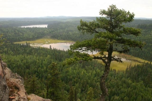
Teapot Mountain Trail is located north of Prince George, British Columbia, Canada. It is a short uphill hike leading to a summit with four viewpoints providing 360 degree views of the surrounding lakes, rivers, forests and wetlands.

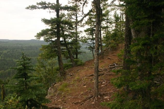
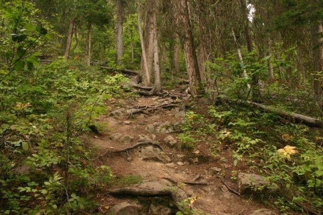
The 1.4 kilometre hike is deceiving because it seems like a short trek on a map but it is not for the light hearted. The trail is a rough grade route and hikers should be in good physical condition. The hike is suitable for families but care must be taken and good hiking boots worn.

The route explores one of two basalt volcanic plugs in the region. The basalt flows formed the interior plateau in the north long before the ice age arrived. The columns of basalt are exposed and visible from the ground on the southern slopes of Teapot Mountain. On the trail the basalt rocks are visible everywhere.

The trail route is covered in exposed tree roots and 5-6 sided basalt boulders. The volcanic rocks formed as the lava cooled and since the basalt is relatively weather resistant the rocks have not shown any signs of wear from the elements which explains why Teapot Mountain survived the last ice age.

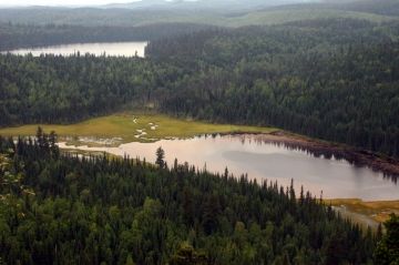
The trail at the top is a circular route exposing 360 degree views. From Viewpoint 1 on the way up the hill provides views of Summit Lake in the south. Viewpoint 2 points towards the marshes and wetlands. The Viewpoint 3 and 4 look northward over many unnamed lakes, creeks, swamps and rivers.

There are no amenities at the trailhead. All hikers must pack out what they pack in.

Explore Teapot Mountain Trails in Prince George, British Columbia, Canada


Address:

Teapot Mountain Trail
Talus Road
Prince George
Canada

How To Get ToTeapot Mountain Trail

:

Drive 50 Km north of Prince George, British Columbia, Canada on Hwy 97 past Summit Lake. From Highway 97 turn left onto Talus Road. Continue driving and then take a right onto the Caine Creek Forest Road. Follow the road to the parking lot.
No reviews yet for Teapot Mountain Trail.

Recently Visited BC Parks

Stoney Hill Regional Park East of Duncan British Columbia Canada
Duncan BC

Stoney Hill Regional Park is in the Municipality o...

Sir George Simpson Historic Landmark - East Kootenay B.C.
East Kootenay Historical Landmark Sir George Simpson

The Sir George Simpson historical landmark is loca...

Bear Creek Falls - Glacier National Park Canada
Revelstoke, B.C

Bear Creek Falls in Glacier National Park of Canad...


Hiking With Your Children - Canadian Rockies Family Hiking Guide
Explore British Columbia
Wells Gray Golf & RV Resort - British Columbia, Canada
Find what Birds to Look For in this Park

Come Experience the Nicola Valley!