Radium Hot Springs
British Columbia
Canada
Park Size: 1,406 sq. kilometresTrail Length: 7 kilometres one-wayDifficulty: ModeratePark Amenities:
Kimpton Creek Trail is a 7 km hiking trail exploring second growth forests and a river eco system in the Kootenay National Park near the Town of Radium Hot Springs, British Columbia, Canada.
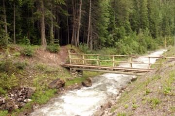
Kimpton Creek Trail starts by crossing a footbridge over Sinclair Creek near Hwy #93. The trail then proceeds along the eastern banks of Kimpton Creek for approximately 5.4 km. The entire trail covers just over 7 kilometres and should take no longer than 4-6 hours to complete.
From start to finish, the elevation gain of the hiking trail is only 335 metres. The trail starts off as a well maintained single track trail following the banks of Kimpton Creek. Most of the trail follows along a mostly pine needle covered, earthy route.
For the first 2 kilometres the trail is level, easy-grade hiking. Then the trail involves into a small series of switchbacks climbing to an elevation of 1470 metres. The trail continues northeast and then drops down again into a second growth forest.
As you get closer to the end of the trail it becomes overgrown and shows signs of lack of use. At this point of the adventure, the trail comes to an abrupt end. There is signage at the end of the hike that directs hikers back down the trail the same way they came up.
The Kimpton Trail is very narrow as it follows the river banks closely. Because of the steam from the Kimpton River the trail is, often, wet and slippery. Good footwear and layering of clothes is important on this hike.
Be aware that the trail involves solid footwork as there are exposed tree roots and river rock throughout the trail. Depending on the time of the season deadfall trees may have fallen across the trail as well.
Kootenay National Park near Radium Hot Springs in British Columbia, Canada.
Address:
Kimpton Creek Trail - Kootenay National Park
Highway 93
Radium Hot Springs
Canada
How To Get ToKimpton Creek Trail - Kootenay National Park
:
How to Get Here: From the Village of Radium Hot Springs travel along Hwy #93 into the Kootenay National Park. Entering the park is a 'west gate' . Continue past the gate for 7 kilometres. Look for a small parking area and trail sign on your right. 100 metres prior to the parking lot is a small footbridge and the Kimpton Creek trailhead.
No reviews yet for Kimpton Creek Trail - Kootenay National Park.