


Join Us
Join Us


Cheam Ridge Regional Trail is a recreation trail which climbs to the summit of Mount Cheam which is located southeast of the community of Chilliwack, British Columbia, Canada. The trail is popular for sightseeing and hiking.
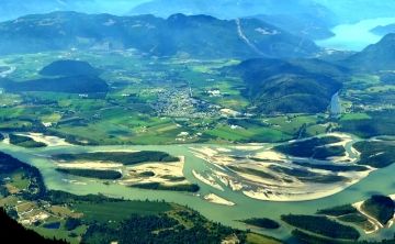
The highlight of the Cheam Ridge Regional Trail are the 360 degree sightseeing opportunities from the mountain summit which include views of the Fraser Valley, Lady Peak, Mount Baker, Jones Lake, Harrison Lake and the communities of Agassiz and Chilliwack.
To access the summit of Mount Cheam one must hike a one-way 4.5 kilometre hiking trail. The trail follows a tough and rugged gravel and dirt path with switchbacks and steep climbs. The elevation gain is about 660 metres from start to finish with a peak elevation of 2100 metres at the summit. The trail is suited for active hikers who are in good condition.
Located along the path are wildflower meadows, creeks, forests, ponds and possible wildlife sightings like bears, cougars, eagles and mountain goats. The Chilliwack path is best hiked in late summer and early fall. At any other time during the year there are possibilities there may be snow at the higher elevations.
From the parking area at the end of the forest service road begin the trail by following the logging road for another 15 minutes. Located on the left will be a trailhead entrance for the Cheam Ridge Hiking Trail. The trail first explores a wildflower meadow and a creek. Hike in late August, early September and the meadow will be a rainbow of colors.
Follow the trail through the meadow and cross the creek. Follow the trail and it eventually hooks up to Spoon Lake. From the lake you continue the gradual climb for about an hour until you reach the bottom of a chain of switchbacks. Good spot to rest before the big climb.
The switchbacks climb up the steep slope of the mountain leading to a ridge and then the summit. Watch for loose rocks. At the top of the switchbacks take a rest and enjoy the views before you continue to the summit. Enjoy the 360 degree views!
Address:
