Icebergs bettered by Trails in Twillingate, Newfoundland
In the central-north region of Newfoundland, Canada is a remote group of islands connected by causeways and ocean ferries. The main islands include Twillingate Islands, Chapel Islands, New World Island, Change Island and Fogo Islands. And then there are the Exploits Islands but they are more like a recreation destination with no road or ferry access – but great for boat tours and kayaking.
Change and Fogo Islands are accessed via ferry only. While New World Island and Twillingate Island are connected by causeways to the mainland. The highway system leading to the region is aptly named the “Road to the Isles” and the highway exploring the region is called the “Islands Experience”. From the main highway (Hwy #1) the main community servicing the region, located at the entrance to the peninsula, is the community of Gander, Newfoundland.
On the west side of the northern group of islands is Notre Dame Bay… and on the east side is Hamilton Sound. Both are of the Atlantic Ocean family. Most of the driving, cycling and hiking enjoyed on the islands is under the watchful eye of the Atlantic Ocean. It is never far and on many occasions it is your side seat driver.
Twillingate, Newfoundland is the main village of the islands. It is the “Iceberg Capital of the World
” except on our visit their were no icebergs. Hmmm… small world? Not that we expected to see any icebergs anyway since they are not usually present at this time of year. The key word being “not usually”. Last week, by a freak of nature, we spotted icebergs in the village of St. Anthony located on the tip of the Northern Peninsula. (pervious post).
The islands are a sightseeing dream come true. The coastline is dotted with history and decorated in rustic charm highlighted by long wooden piers, dory boats, seaside shacks, lobster traps, polished boulders and crooked docks. Located just off shore… the Atlantic Ocean displays some of its finest artwork and carvings like sea stacks, rock pillars, sea caves, rock arches, wetlands, wildflower headlands, jagged cliffs and a private collection of sandy, pebbled and boulder beaches.
Twillingate, Newfoundland and in many ways Durrell, Newfoundland are the base camp communities of the islands. Twillingate and Durrell, both small villages, are so close together they seem like one community. There are a few restaurants, shops, attractions and art galleries. By far, the most visible business venture are the wildlife sightseeing tours providing boat tours viewing icebergs (when they are around), whales and puffin birds. The tour companies operate out of some of the most colorful and unique buildings located on the waterfront strip.
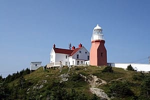
However… if the outdoors and exploring remote coastline beauty is your thing then you have to plan for some time to explore the day hiking trails in the region. We were first attracted to the region because of the Long Point Lighthouse. Once we familiarized ourselves with the region there was allot more to offer. Their are trails following cliffs high above rocky coves and remote sandy beaches. There are trails walking through stunted forests and wildflower fields of blues, purples, whites and yellows. There are trails dissecting wetlands and side stepping around cliff side gorges. Some trails walk over boulders, some follow boardwalks, some lead to lookouts while many are old fashion and follow a gravel, dirt and earthy pathways.
The selection of trails and scenery is remarkable since it is not located within a park system. The islands have developed a trail system all on their own. And there are a ton of them and most are well signed and maintained. Each trailhead was easily marked and located. The trails were left in many ways in a natural state. And… most are single track, wilderness trails complete with exposed tree roots and boulders. Although there are some which follow a gravel access road.
In and around Twillingate, Newfoundland there is a trail system called the Twillingate Islands Coastal Trails. There are too many trails to list but here are some of the more popular trails we researched – Sleepy Cove, Devils Cove, French Beach, Cojacks Cove and the Lower Little Harbour Trails. They all delivered a prize at the end of the trail! If I were to pick one to talk about here it would have to be the French Beach Trail.
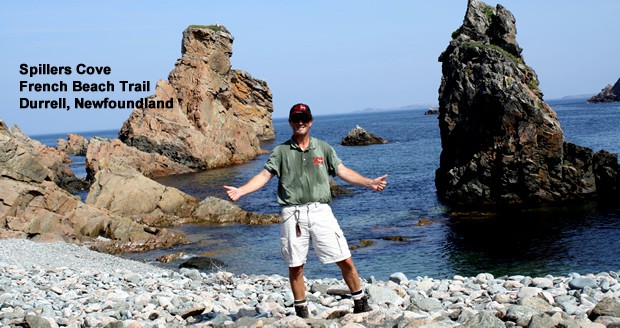
The French Beach Trail was one of the favorites on this trip. The route led us to pebbled and sandy beaches, private coves, sea stacks and unique rock formations. The route often looked down on gorges and sea caves. In our sights, most of the time, was ocean blue splattered with images of islands, cliffs and white water waves. When the trail wandered away from the coast we walked on or around giant boulders and rocks like Armstrong did on the moon.
The loop hiking trail measures about 4.5 to 6 kilometres long depending on which “out” trail you access so to return back to the parking lot. Some do the whole nine yards connecting to the Cojacks Cove Trail from the French Beach Trail making it a longer one-way hiking adventure.
The French Beach Trail on its own is a treat no matter which route you decide on. It begins by first following a rocky, grassy headland path with an amphitheatre-like view looking out over the ocean. All the while the path passes by sea stacks and side steps around gorges. After a short 300-400 metres the pathway slowly begins to drop down into a pebbled beach called French Beach. The pebbles are all polished and smooth, rolling up and down the shoreline in time with the incoming and outgoing tides like singing sands.
At the far end of the beach the trail picks up again and crawls up out of a gorge before dropping you on top of another raised headland. I was exposed to the elements. The winds were blowing and warm and I felt so alive! The views began to exceed my expectations once again. My eyes were so blurred from the wind… or were they tears of joy.
The trail route then follows the coastline to French Head. Some of the best coastline views are from the rocky perches overlooking French Head. It is here the coastline’s jagged teeth bares all with sharp cliffs, gorges and unique rock formations. Waves are crashing the cliffs and the white water mist is getting some big time air. Some rocks resemble images and are famous with names like Cobra Snake, Camel and Indian.
From French Head the trail veers inland back and forth on its way to Spillers Cove. Just pass French Head there is an “out” trail leading back to the parking lot. The trail to Spillers Cove walks through a field of boulders and rocks. At times the trail dips back to the coastline and the scenery reappears… a good time for a break so to appreciate nature at work.
Prior to Spillers Cove there are a few gorges with towering walls. And at Spillers Cove there is an access path leading down into a cove and onto a private pebbled beach. On this trip the beach was all mine… and there was no need to share. Not a soul in sight… so I made my way down to the beach and enjoyed some quality time with a sea stack up close and personal. Back on top of Spillers Cove there is a trail map and a sitting bench. It was time to contemplate the route to be taken… hmmm… what to do? You see from Spillers Cove one can continue along the coastline and hook up to the Cojacks Cove Trail or take the “out” trail back to the parking lot. Hmmm…


Leave a Reply
Want to join the discussion?Feel free to contribute!