Blow Me Down in Newfoundland
We set up our Base Camp near the community of Corner Brook, Newfoundland. It is the hub city on the west coast of Newfoundland. From our Base Camp we were going to snoop around a bit and research the community and the surrounding coastline.
The weather was still playing cat and mouse with us. Lately we have been getting a blender full of weather. The early morning fog we have been getting is freaky cool… it wakes us up, follows us around at our knees in the morning and sometimes sucks us into its mist disappearing from sight. Later in the day… when we play nice I guess… the sun would dance for us and tease us by throwing heat on our faces.
Down the road from Corner Brook is Marble Mountain. It gets an honorable mention because it is one of the main ski and snowboard resorts on the island. We are avid snowboarders and ski mountains are our friends. However… this is a summer blog entry so we must stay focused.

Corner Brook Views from Capt. James Cook Lookout
In the community of Corner Brook we visited the James Cook Historic Site and went exploring the community trail system called the Corner Brook Stream Trail. It is a walking and biking trail system good for exploring throughout the region visiting with the waterfront, parks, downtown, a canyon, rivers and forests.
Up on a hill located behind the community of Corner Brook is the Captain James Cook Historic Site. James Cook arrived in Canada in 1758 as part of the Seven Year War between the British and French. He soon became a cartographer and surveyor plotting some of the first maps of the region.
The historic site provides a replica of the first map of the region drawn by James Cook and some historic information boards on the captain himself. The site is also a popular sightseeing viewpoint providing far reaching views of the city, waterfront and neighbouring cliffs.

Fisherman's Cove on Hwy #450
More adventure was waiting for us on Highway #450 which is located west of Corner Brook. The long 2 lane highway twists and turns along some low lying coastline and high flying cliffs. The road led us to the Blow Me Down Mountains. We visited the fishing villages, parks and hiking trails in the backyard of the mountains.
Blow Me Down Provincial Park is nestled tightly in between the Lark and York Harbours. There is a beach, day use area, picnic area and hiking trails. The views include the Blow Me Down Mountains and the Bay of Islands.

Governer's Trail Lookout in Blow Me Down Park
Blow Me Down Provincial Park is best viewed from the Governors Staircase Trail. The 750 metre trail follows a series of stairs straight up a mountain cliff connecting to a lookout. It is a steep climb but a short one. There is a resting bench and a small viewpoint at about the 250 metre point of the trail. Some may choose to go only this far. For others continue climbing to the top of the mountain and there is another lookout platform with far better views of the entire region.
From the mountain top lookout the trail continues for the curious. A one-way 3.5 kilometre hiking trail continues along exploring cliffs and forest. It is more of a wilderness trail. The route follows an earthy, sometimes muddy, path covered in exposed tree roots and boulders making high stepping and good foot work a plus.
At about the 150 metre mark from the main trailhead there is also another access path leading down to some sea caves. Check the tides before going down as it is best viewed at low tide and coming back up steep stairs may be an avoidable punishment.

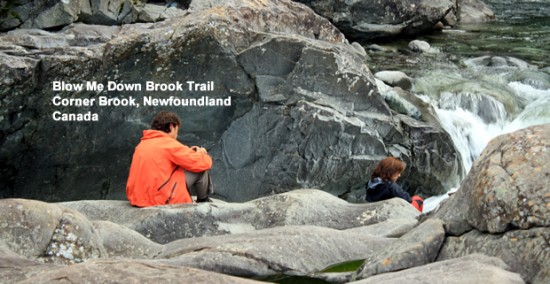
Blow Me Down Brook Trail Canyon
On my trip back from the park I had a choice of two trails. I pondered and “hummed and hawed” for a few seconds on which one I should do… soon later I decided on the Blow Me Down Brook Trail over the Copper Mine Cape Trail.
The Blow Me Down Brook Trail explores up into the Blow Me Down Mountains for many kilometres. Along the route, maybe a long 2 kilometres into the trail, there is a short side-access trail leading down into a canyon and some river pools with cascading rapids and giant boulders. It is a very romance novel-ish spot.
The pathway is a fairly level and easy going route. It follows, what seems to be, an old dried out creek bed for most of the route before leading down into the canyon of river pools.

Blow Me Down Brook Trail Canyon Rapids
The canyon is nirvana in many ways. It closes you off from the outside world letting nature take over your thoughts. The rapids are loud and the white water dances and bounces off the many river boulders. Everywhere are giant size boulders… shaved and silky smooth from years of wind, rain and river. What is there not to like?
I have read so many posts on the topic of the blogger lovers except
this article is actually a nice paragraph, keep it up.