


Join Us
Join Us


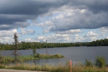
Quetico Provincial Park is a year round wilderness recreation destination located south of the community of Atikokan in Northwestern Ontario, Sunset Country. The 475,782 hectare park (1,180,000 acres) rests on the Canada/USA border and crosses into the southern boundaries of the Canadian Shield.
The park is a top adventure destination in Ontario, Canada for canoe paddle routes and wilderness backcountry camping. There are over 600+ lakes, over 2000+ wilderness campsites and 80+ kilometres of portages. The connecting river and lake systems extend outside the park and connect to as far as Hudson Bay.
At the south end of the Quetico Provincial Park - across the border in Minnesota, United States - is the Superior National Forest and the Boundary Waters Canoe Wilderness Area. Together, with the Canadian park, they provide an endless network of canoe routes to explore.
Long ago the rivers and lakes were paddle routes used for transportation, hunting and fishing by the First Nation people of the region especially the Ojibway First Nation people. Later the rivers and lakes became transportation routes traveled by fur traders and voyageurs seeking the new world and trade routes.
It was not until 1909 did the region first become a protected forest reserve. And in 1913 the region was officially named the Quetico Provincial Park making it one of Canada's oldest parks.
The park, once a reserve, is very much still untouched by man. For the most part the rocky cliffs, lakes, rivers, forests, wetlands, waterfalls, wildlife and flowering meadows have been left under nature's supervision.
To this day there are no roads leading into the park. However... there are 6 ranger stations located in the park which act like check points and operate as entrance gates into the park. Four of the six ranger stations are accessed by water only. Two can be accessed via road.
Waterway access ranger stations include the Cache Bay and Prairie Portage ranger stations located along the Canada and USA border. The Beaverhouse and the Lac La Croix ranger stations are near the Lac La Croix First Nations Reserve.
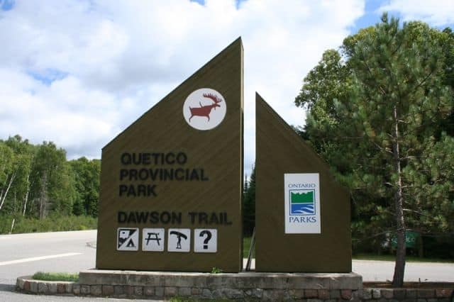
The only ranger station accessed by vehicle located within the boundaries of the Quetico Provincial Park is the Dawson Trail ranger station. It is located in the Dawson Trail Campground. Dawson Trail Campground includes Pickerel Beach which is located on the shores of French Lake.
The Dawson Trail Campground includes serviced and unserviced camping sites, as well as, showers, washrooms, playground, canoe launch, laundromat, day use area, picnic tables, Park Office and gift store.
Located in and near the park are many developed accommodations including cabins, cottages, yurts, lodges and a heritage house. Outside the park one can drive to the community of Atikokan, Ontario and visit the ranger station in town for information, maps and permits.
Permits are required to canoe and camp in the park. The 6 ranger stations assist acquiring permits, provide maps and oversee 20+ entry points into the park.
The park provides an endless supply of canoe routes to explore. Too many to list here. However, here are a few paddle routes which start from a few of the ranger stations worthy of your consideration.
Dawson Trail ranger station is a put-in canoe destination for accessing the 123 kilometre (76 mi.) long Baptism Creek and Cache Lake Loop Paddle Route. The paddle route explores 18 lakes connected by 20 portages. It is considered a challenging canoe route exploring some of the most rugged portages in the park - the northeast corner.
Atikokan ranger station is a canoe destination for accessing the 112 kilometre (70 mi.) long Batchewaung-Twin-Jean-Jesse Loop Paddle Route. The paddle route explores 14 lakes and includes 18 portages. Again another challenging route with many lakes and portages covering long distances.
Beaverhouse ranger station is a canoe put-in point for accessing the 64 kilometres (40 mi.) long Cirrus Lake-The Sue Falls Loop Paddle Route. The route explores 5 lakes and includes 7 portages. Long sections of paddle activity with a few short portages.
Prairie Portage ranger station is a put-in point for accessing the 609 kilometre (379 mi.) long Carp Lake-Hunter's Island Loop Paddle Route. The canoe route explores 25 lakes and includes 29 portages. A 2 week canoe route exploring a section of a historic paddle route called the Voyageurs' Highway.
On land the Quetico Provincial Park provides a selection of hiking trails ranging from 1 to 10 kilometres, from easy to challenging.
The Beaver Meadows Trail measures 2.5 kilometres (1.6 mi.) and is considered a moderately challenging hike exploring a forest with steep elevations, rugged terrain and sections which can be slippery.
The French Falls Trail measures 2.4 kilometres (1.5 mi.) and is a moderately challenging adventure exploring a river bed with some steep elevation hiking. The moist conditions can make the trail slippery in sections. The rapids make for good photos.
The French Portage Trail measures 5 kilometres (3.1 mi.) and is considered a challenging hiking trail which follows a portage route connecting Windigoostigwan and French Lake which was the route used by the early First Nation people and voyageurs.
The Pickerel Point Trail measures 1.6 kilometres (1 mi.) return and is considered a challenging route following the banks of a river leading to a viewing area. There are sections of the trail which are steep. Great for birdwatching at the point.
The Pickerel River Trail connects the the information centre with the French Lake Day Use Picnic Area. The route is called the Sheila Hainey Boardwalk and it measures 0.8 kilometres.
The Pines Hiking Trail measures 10 kilometres (6.2 mi.) return and is considered a moderate trail highlighted by beaches, forest and wilderness camping opportunities. The trail connects to the Whiskey Jack Trail.
The Whiskey Jack Trail measures 2.5 kilometres (1.6 mi.) and is considered a major entry trail leading into the park. The hiking route explores a forest environment while following a boardwalk and dirt trail.
Other activities enjoyed in the park besides canoeing, wilderness camping and hiking include swimming, birdwatching, wildlife sightings, sightseeing, picnicking and fishing for lake trout, smallmouth bass and walleye.
In the winter months the Quetico Provincial Park becomes a popular destination for ice fishing, xc skiing, winter camping and snowshoeing.
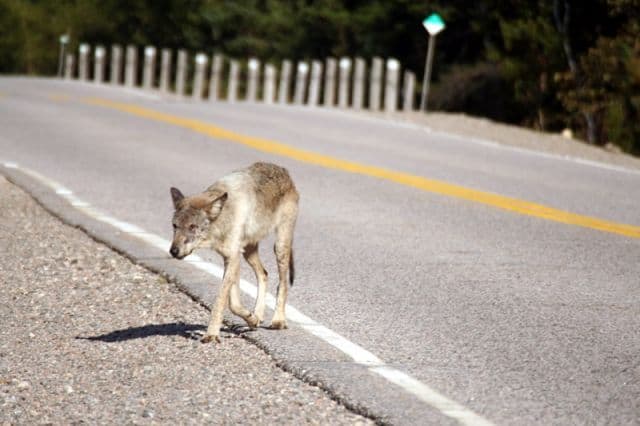
The park provides many opportunities for wildlife sightings. Some of the most popular sightings include moose, bear, otter and beaver. Birdwatching includes waterfowl, song birds and predator birds like Bald Eagles.
Address:
