Lac du Bonnet
Manitoba
Canada
Park Size: 4,000 square kilometresPark Amenities:
Atikaki Provincial Park is a wilderness park left to its own resources, untouched by man, located in the Eastern region of Manitoba, Canada. It is a rough country, a ruggedly beautiful country and a popular "bumps and bruises" adventure destination for the most experienced outdoors person.
The Atikaki Provincial Wilderness Park measures 4,000 square kilometres. There are no roads leading into the park. There are only rivers and air space. The rivers are the paddle routes leading in and out of the park. And the floatplanes fly in and out of the park dropping people off at remote lodges, outfitter camps and cottage resorts.
The wilderness park is referred to as "Shield County" because the landscape consists of some of Canada's oldest rock - the Canadian Shield. Decorating the shield is a boreal forest and a network of bogs, marshes, lakes, wetlands and over 1,000 kilometres of rivers.
The park is named after a First Nation word from the language of the Ojibwe people. Atikaki in Ojibwe means "country of caribou." Today, a herd of caribou access the park as it is part of the Atikaki-Berens Caribou Range. The number of caribou are estimated to be in the low hundreds.
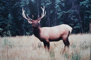
Living with the caribou in the Atikaki Provincial Park are some other, pretty famous, wildlife figures. Other wildlife in the park include mammals, amphibians, reptiles and birds. There are black bears, moose, elk and birds like bald eagles, osprey, owls and plenty of waterfowl.
The main adventures enjoyed in the remote wilderness park include canoeing, fishing, birdwatching, white water rafting, hunting and wilderness camping. Always make sure to keep a keen eye open while exploring for some First Nation pictographs painted on the rocks and cliffs.
For adventures in the park some fly in to remote lodges and camps. Others travel the rivers by canoe. The Atikaki Provincial Park delivers canoe routes for the experienced paddler. There are paddle routes exploring for a couple of days and there are opportunities to paddle for weeks.
There are many routes to explore like the Bloodvein River, Pigeon River, Gammon River and the Sasaginnigak River. The Bloodvein River in the park is a Canadian Heritage River. It has a long First Nation history. The Pigeon River is where to go for the extreme white water paddle routes.
There are opportunities to wilderness camp in the park. Camping spots are determined by the already existing fire rings. Please try to keep to these areas so to minimize the damage on the environment as much as we can. Remember... pack out what you pack in.
It is important to prepare well for canoe adventures in this wilderness park. The river route and terrain must be well mapped out. Equipment must be top notch. Survival skills are a must for emergencies. If this is not you, do not attempt to canoe in. It would be wiser to sign up with a tour group with an experienced guide.
The Atikaki Provincial Park is located north of the Nopiming Provincial Park and Whiteshell Provincial Park in the Eastern region of Manitoba, Canada.
Atikaki Provincial Park, Manitoba, Canada
Address:
Atikaki Provincial Wilderness Park
Lac du Bonnet
Canada
How To Get ToAtikaki Provincial Wilderness Park
:
How to Get Here: There are no roads into the park.
Access to the park is best by floatplane, bush plane or canoe. Riverton, Lac du Bonnet and Bissett are small communities with fly and canoe access into the park.
Canoe paddle route maps are available in Lac du Bonnet and Bissett.
No reviews yet for Atikaki Provincial Wilderness Park.