Pender Hill Hiking Trail

Pender Harbour
Trail Length: 3 km return
Difficulty: Difficult
Park Amenities:
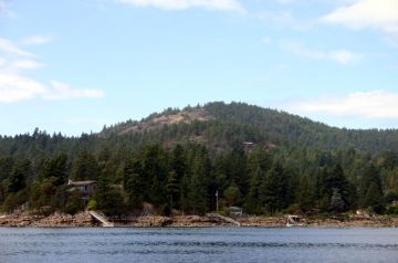
Pender Hill is another quick trek filled with hard hiking with great scenic views The trail is steep and can be slippery, so keep alert. The hill itself is only 231 m (758 feet) high but the trail starts climbing quickly straight up.
The Pender Hill Trail covers 3 km (2 mi.) return trip. Up being harder than down, I hope you have figured that out. Depending on fitness levels the hike up Pender Hill takes 1/2 -1hr to complete.
The summit of the Pender Hill shows off views of the Sechelt Peninsula and Pender Harbour. The views come with entertainment too as sailboats, fishing boats, yachts and motor boats travel back and forth out of Pender Harbour.
History tells us the Sechelt Fist Nation people used Pender Hill as a look out for scouting out any threats that could be coming around the corner into the harbour. The area was said to be the preferred look out point because it gave a better perspective of the "comings and goings" of Pender Harbour. The other look out point overlooking Pender Harbour and lakes is on Daniel Mountain.
High above, on the peak of Pender Hill, the natural rock gardens are still evident. Explore some more and find the Arbutus Tree cluster shedding their bark . Also look for the the old fire station lookout. Good opportunity to maybe see a Bald Eagle swoop down from the sky.
Pender Hill Hiking Trail, Pender Harbour, Sunshine Coast, BC
Address:
Pender Hill Hiking Trail
Lee Road
Pender Harbour
Canada
How To Get ToPender Hill Hiking Trail
:How to Get Here: Follow Hwy 101 north from Pender Harbour. 5km (3.4 mi.) north of Madeira Park turn west off Highway 101 onto Garden Bay Road. Approx. 8 km from the Garden Bay Rd look to turn right onto Lee Road. Park and hike people!
No reviews yet for Pender Hill Hiking Trail.
