Fairy Creek Falls Trail, Fernie

Fernie
Trail Length: 7 kilometre
Difficulty: Moderate
Park Amenities:
Fairy Creek Falls Trail is a hiking route exploring along a small creek leading to a viewpoint overlooking a 5 metre waterfall. The wilderness trail is located in the community of Fernie, BC in the East Kootenay region of British Columbia, Canada.

The Fairy Creek Falls Trail explores the lower slopes of Mount Proctor eventually connecting to the base of the Three Sisters. The trail is considered a moderately easy route with some switchback hiking along a, mostly gravel trail. The one way 7 kilometre trail has an elevation gain of 260 metres (855 ft.).
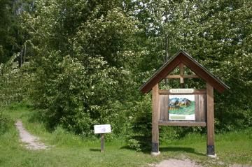
The trailhead begins behind the Fernie Info Centre. It begins as a connector trail before actually hiking on the true trail. From the trailhead follow the blue tree marker flags past a big field to a fence line. Cross the cattle guard.
The larger trail leading toward the power lines is the Mt. Proctor Trail. The narrow hiking trail situated between the fence and the Mount Proctor Trail is the Fairy Creek Falls Trail. There is a viewpoint over the waterfall and a picnic table at about the 3.5 kilometre mark.
From the waterfall one can hike back to the parking lot near the info centre or continue further connecting up with the longer Mount Proctor Trail. The longer trail is a full day adventure. All mountain hikers should be well prepared for weather and climate changes. Also be aware this is bear country.
The Fairy Creek Falls Trail explores the lower slopes of Mount Proctor eventually connecting to the base of the Three Sisters. The trail is considered a moderately easy route with some switchback hiking along a, mostly gravel trail. The one way 7 kilometre trail has an elevation gain of 260 metres (855 ft.).
The trailhead begins behind the Fernie Info Centre. It begins as a connector trail before actually hiking on the true trail. From the trailhead follow the blue tree marker flags past a big field to a fence line. Cross the cattle guard.
The larger trail leading toward the power lines is the Mt. Proctor Trail. The narrow hiking trail situated between the fence and the Mount Proctor Trail is the Fairy Creek Falls Trail. There is a viewpoint over the waterfall and a picnic table at about the 3.5 kilometre mark.
From the waterfall one can hike back to the parking lot near the info centre or continue further connecting up with the longer Mount Proctor Trail. The longer trail is a full day adventure. All mountain hikers should be well prepared for weather and climate changes. Also be aware this is bear country.
Address:
Fairy Creek Falls Trail, Fernie
Commerce Road
Fernie
Canada
How To Get ToFairy Creek Falls Trail, Fernie
:How to Get Here: Travel to the community of Fernie, BC along Highway #3. Stop and park at the Travel Information Centre on Commerce Road located just off the highway. The trailhead is marked at the back of the parking lot.
No reviews yet for Fairy Creek Falls Trail, Fernie.
