


Mount Arrowsmith Regional Park

Park Amenities:
Mt. Arrowsmith
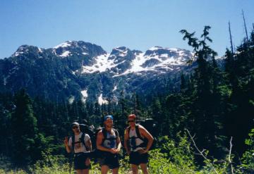
Mount Arrowsmith is a year round wilderness recreation destination located east of the community of Port Alberni, BC on Vancouver Island, Canada. The mountain measures 1,819 meters high making it the highest mountain located on Southern Vancouver Island.
The backcountry roads and recreation trails located on Mount Arrowsmith are popular for many activities. In the summer months mountain biking, hiking and horseback riding are popular. In the winter the snow covered gravel roads and trails become backcountry ski and snowshoeing routes.
The highlight on the mountain would be the Mount Arrowsmith Trail. It is a long day hike leading to the peak of Mount Arrowsmith and fantastic views. The hiking route is about 3.5 kilometres one way to the peak. A total elevation gain of 1000 metres. A return trip to the peak and back (7 kilometres) would take about 4 -6 hours depending on your fitness levels.
The hiking trail is considered an intermediate hike with some difficult sections. The trail is marked by flags and tree markings. The trail markers can be spotty at times. Prepare for some steep sections along the trail. Some sections are not well maintained and can get slippery. Watch for exposed tree roots and loose rocks. All hikers should prepare for mountain elements like winds, changing temperatures and unpredictable weather.
On the peak of Mount Arrowsmith is a radio tower and a Hiker Registry. Make sure to sign the book and leave your mark. The views from the summit are amazing. On a clear day there are 360 degree views. One can see the entire Alberni Valley, many of the Coast Mountains and parts of the Pacific Ocean.
How to get to Mt. Arrowsmith
Travel to the community of Port Alberni, BC on Vancouver Island via Highway #4. Before the big hill leading down into town at about the 9 kilometre mark, east of Port Alberni, is a gravel dirt road marked by a backcountry Arrowsmith ski sign. Turn here. Drive for 3 kilometres and then turn onto Cameron River Main Forestry Road. Follow the markers for another 3 kilometres to the trailhead parking lot. Beware gravel roads may not be suitable for all vehicles.
Address:
How To Get ToMount Arrowsmith Regional Park
:
Recently Visited BC Parks