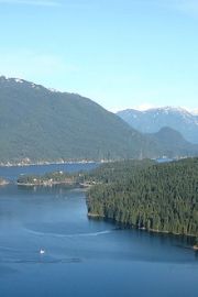

Indian Arm Provincial Park

Park Size: 6,826 hectare
Park Amenities:
Most of the 6,826 hectare park protects the middle to top portion of the fjord. The park eco system consists of lush forests, mountains, wildlife, alpine lakes, islands, waterfalls, creeks and rivers.
The Indian Arm Provincial Park is special, in that, it provides exceptional water and land adventures... yet it can only be accessed by water craft and trails. There are no real access roads leading into the park. The best access into the park is by boat, kayak and canoe or by hiking trail.
Scuba diving and fishing is also enjoyed in the park. Scuba Diving is best enjoyed exploring the reefs around Racoon and Twin Islands.... and also Croker Island should get an honorable mention for scuba diving.
River fishing is best on the lower sections of some rivers and ocean fishing is best near the islands. Indian River provides the best river fishing opportunities for catching salmon, cutthroat and steelhead.
Campgrounds are marine access only. There are campgrounds at Granite Falls (location of 50 metre waterfall), Bishop Creek and North Twin Island. Campgrounds are primitive and rustic. Tent pads are available at Granite Falls (gravel pads), Bishop Creek (grass pads) and North Twin Island (wooden pads) campsites.
Docks are available near the North Granite Falls and North Twin Island campsites. A rocky beach and a rustic, grassy day use picnic site is located near the dock at Granite Falls. Picnicking with no facilities is also possible near the mouth of Bishop Creek and on Twin Islands.
The Indian Arm Park is managed by Parks Canada and the local First Nation people. The park has a long history with the First Nations especially the Tsleil-waututh and Musqueam people. The evidence of their long history is told by the pictographs found throughout the park.
Some of the wildlife sightings in the park include black bear, deer, coyote, cougar, red fox, wolves and harbour seals.
Diez Vista Trail (7 kms one-way) - considered a challenging trail with an elevation gain of 460 metres. The trail is a sightseeing route with many opportunities for marine and wilderness views of Indian Arm and Burrard Inlet. The route includes some steep climbs, switchbacks, exposed tree roots, dense forest and high cliffside views. Trail exit is near dam on Buntzen Lake. Return to starting point via the Buntzen Lake Trail (easier route).
Access trailhead entrance from the floating bridge on the south end of the reservoir in the Buntzen Lake Recreation Area and from the Saddle Ridge Trail in the Belcarra Regional Park.
Lindsay Lake Loop Trail (15 kms) - great views on a very challenging trail with an elevation gain of 1030 metres. The route includes some steep climbs, switchbacks, exposed tree roots, boulders, dense forest and high cliffside views. The trail explores along the banks of Rogue and Buntzen Creek before reaching the El Paso Junction. Take a left and climb to Barton Point and the Little Valhalla Lookouts. Continue along Spahat Ridge, pass Jessica Lake, to West Point, The Pulpit and eventually to Lindsay Lake before connecting to a junction with the Swan Falls Loop Trail. Take a right and loop around Lindsay Lake and head south to a another loop trail junction. Take a right and visit St. Mary's, Jay and Mac Lakes.... or take a left and visit Chickadee, Demelza, Robin and Siskin Lakes. Either route reconnects with the main trail near the El Paso Junction. Hike back the same way you came.
Access trailhead entrance from the parking lot near the main entrance gate to the Buntzen Lake Recreation Area.
Dilly Dally Loop Trail (25 kms) - great views on a challenging trail with an elevation gain of 1150 metres. The route includes some steep climbs, switchbacks, exposed tree roots, boulders, dense forest, rock slide and high cliffside views. First you explore along the banks of a creek and through a forest called the Lower Gully (Swan Falls Trail) until you reach the Swan Falls Junction. Take a left and climb up to the 117 Lookout and the Dilly Dally Pass. Tough haul. From the pass you begin your downwards climb on an old logging road back down to the end of Powerhouse Road in the Buntzen Lake Recreation Area. It is also a snowshoe route in the winter season.
Access trailhead entrance from Powerhouse Road near the suspension bridge and staging area for horseback riders in the Buntzen Lake Recreation Area. The Swan Falls Trail is trailhead entrance.
Swan Falls loop Trail (20 kms) - great views on a challenging trail with an elevation gain of 1150 metres. In short the trail is a combination of the Dilly Dally and Lindsay Lake Loop Trails.
Explore Indian Arm Marine Provincial Park near Port Moody, British Columbia, Canada
Address:
How To Get ToIndian Arm Provincial Park
: