Cape St. Mary Ecological Reserve Birding on High

Bird Rock at Cape St. Marys Ecological Reserve
We have traveled almost full circle… hard to believe really since we did it on a shoe string budget overcoming many opportunities and obstacles along the way. However… our determination and a will to succeed prevailed. Now we must focus on putting all the information we collected together building our EH Tourism travel websites on our CanadaEH.net Travel Network of websites.
We have followed our cross country route that we scratched out on our Canada map from Vancouver Island on the westcoast of Canada to the eastcoast of Newfoundland. According to most sources Canada measures out to be around 5000+ kilometres long – west to east – depending on who you ask. Our mileage metre was blown off the charts as we clocked about 400,000+ kilometres west to east and north to south over and over again, doubling back, zig zagging here and there playing an aggressive game of cat and mouse with nature.
The final destination completing this leg of our cross country research mission for this year was the Agentia Ferry Terminal located near the community of Placentia in Newfoundland, Canada. The terminal was our finish line on the Avalon Peninsula.
The ferry transportation across the Atlantic Ocean from Agentia, Newfoundland to Sydney, Nova Scotia is a whooping 12 hour tour. But first there was work to be done. Before we set sail we spent a few days researching the Cape Shore Highway Route exploring a peninsula located south of the village of Placentia, Newfoundland.
The sightseeing road sweeps around corners, crawls up and down hills and drops down into villages crowded by cliffs and hidden by coves and bays. There are no major services or communities on this route. It is small town Newfoundland all the way. The destinations which made our short list – ones we deemed worthy of your time – included the Cape St. Mary Ecological Reserve, Gooseberry Park and Cataracts Park.

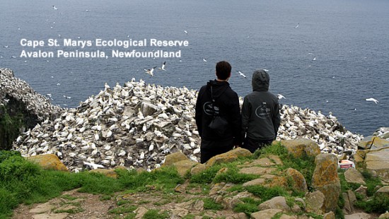
Bird Soaring Cliffs - Cape St. Marys Ecological Reserve
The highlight of the region was the very popular birding site called the Cape St. Mary Ecological Reserve. The reserve is the largest birding colony of its kind in North America. It is home to the largest gannet birding colony in Newfoundland and the world’s most southerly colony of Thick-billed Murres. Other birds viewed on the cliffs of St Marys include the Black-Legged Kittiwake, Razorbills, Black Guillemots and Cormorants.
It was not just one or two birds flying around. There were thousands! The Cape St. Mary’s Ecological Reserve is a prime birdwatching destination in eastern Canada. A must see destination for any avid birdwatching or nature enthusiast.
The site was easily accessible via a long 13 km paved road. The road leads you into a tunnel of fog on most days… but not on this day. For some reason the fog lifted its choke hold on the peninsula as I approached the parking lot. There was still a haze in the skies, making views fuzzy at times when looking from afar. But I could see and that to me makes my job allot easier. Pictures and video in the fog is like taking a picture of a white wall.
From the parking lot I wandered over to a lighthouse. It sat alone looking cold and peeling with emotions. It had seen better days. In the other direction was the Interpretive Centre. Inside the centre a guide asked if I had hiked the trail to view the birds? I had not. I was quickly reminded that the fog rolls in race-track fast and I should quickly take advantage of the sights and sounds of the birding colony now before the fog returns in a bad mood clouding our views and judgments.
Do not need to tell me twice. I was outta there and on the trail leading to the birding colony before the guide could finish his sentence. From the interpretive centre there is a one way 1.5 kilometre trail crossing over grassy headlands before coming to an abrupt cliff. From the cliff’s edge there was a natural viewing area while standing on boulders. There was no fence and it is not a kid proofed area so keep the young ones close.
The views were amazing. There were canyons, sea stacks and rock cliffs. The sea stack located at the end of the trail is called Bird Rock. Makes sense since every bird seemed to flock to the rock pillar. There were birds grooming each other – squawking and screaming in pleasure like a bad house band… and there were birds dive bombing from the high cliffs like an Olympic diver on a Gold Medal run.

Gooseberry Park Sandy Beach
From the Cape St. Mary’s Ecological Reserve on the tip of the peninsula I worked my way back to Placentia. On my way back I diverted towards the Gooseberry Provincial Park. It was not an easy find. There was no park sign, no highway sign hinting it was coming up and no clear entrance way. Because of my research radar I spotted a picnic table and that is always a good sign of a park nearby. But still no entrance? I soon figured the driveway-like entrance to some houses was the actual entrance to the park.
Gooseberry Park was simple with not allot of flair or care. There was one picnic table. I bet the fight for the picnic table was an interesting story to watch unfold on a nice day. There was no real parking lot but more of a turn around. The park relied solely on the sandy beach for attention. And attention it got as people were building sand castles and playing in the surf.
The Cataracts provincial Park was another treasure hunt of a find. The park was located 21 kilometres down a gravel road. Again there was no sign of the upcoming park, no park entrance so I had to rely on my research radar skills again. I came across a gravel parking area in the middle of nowhere.
Hmmm… gravel parking lots are either a trailhead or a staging area for off roading or snowmobiling when they appear out of nowhere with no real meaning. So I played a hunch and pulled in and parked. I took a scan of the area for evidence of a park like Sherlock Holmes surveying a crime scene. That was when I spotted a boardwalk trail poking out of the tress on the opposite side of the road. Eureka!

Waterfall in Cataracts Park
The trail connected to a series of boardwalk stairs which dropped dramatically into a canyon gorge. On the floor of the canyon there were some viewing areas peering out onto some cliffs and a large cascading waterfall crashing into a large pool of water. The scenery was spectacular and in some ways very therapeutic as I have a huge love for waterfalls. I sat and listened for some time. Not a soul was around so nature and me enjoyed some quality bonding time.
I drove back on the gravel road and let my day playback in my mind like rewinding a good movie for the good parts. I smile broke out and then disappointment crept in as I asked myself, ” How many people missed this beautiful spot because of poor marketing and maintenance?” When will tourism learn nature creates lasting memories and grows repeat tourism.
Leave a Reply
Want to join the discussion?Feel free to contribute!