Ice Cube Sightings and Viking Battles in St. Anthony, Newfoundland

Iceburg Sighting in St. Anthony, Newfoundland
From the beautiful Gros Morne National Park near Deer Lake, Newfoundland we drove further north following the Vikings Highway to the tip of the Northern Peninsula and the small community of St. Anthony. From the cliffs, beaches and photo album hikes in the Gros Morne National Park we now turned our attention towards Viking History and Iceberg Alley in St. Anthony.
St.Anthony is, pretty much, as far north as we could go while exploring Newfoundland on land. While traveling the Vikings Highway on the way to St. Anthony we passed the ferry terminal for connecting to Labrador… which would lead us deeper north… but that is for another day down the road when we make the time to do it right.
St. Anthony is perched on the scenic coastline of Iceberg Alley. The alley is actually an Arctic ocean channel with very strong currents acting as a highway for icebergs. Every year icebergs. float down the channel and visit in the coves and bays of some of the coastline villages.

Big Ice Cubes in St. Anthony
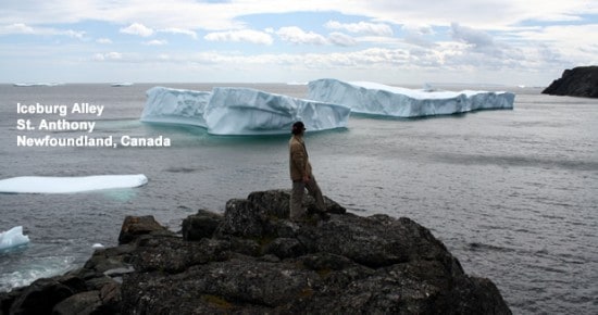
From the cliffs and boulders in Fishing Point Park in St. Anthony there are walking trails and lookout viewpoints providing fantastic scenery and front row seats to iceberg sightings. Here is the trick. Off the coast of Newfoundland good iceberg traffic and sightseeing is usually between the months of April and July. But because of the abnormal colder weather this year the icebergs. are not melting as fast. So when we showed up at Fishing Point Park in St. Anthony in August we were jumping hoops when we saw the giant, frozen “burgs” floating in the harbour.
Soon later we came down from our iceberg adrenaline rush and started talking about how much the climate is changing and setting off different weather patterns across the globe and in our own backyard. Icebergs. in August is not right. We were fortunate we saw icebergs. even grateful, some would say somewhat selfish… knowing, full well, that global warming probably provided us the opportunity.
The icebergs. in St. Anthony came in all shapes and sizes. Some were giant square blocks like their smaller cousins the ice cube. Some were monsters, chiseled and sculpted by nature, as if they were exhibits in an outdoor art gallery. Many “burgs” looked trapped in coves and bays with nowhere to go. Some floated far off in the distance where the ocean meets the horizon. Together, they all dominated the scenery and were the stars of the show.

Viking Sod Building in L'anse aux Meadows Park
Just north of St. Anthony is the L’anse aux Meadows National Historic Site. The L’anse aux Meadows Park is Viking country. The park is situated on the most northern tip of the peninsula. The historic nature of the park is due to the discover of Viking remains and artifacts dating back to 1000 AD I believe? In fact, they uncovered some old footings of a Viking village and the site is still on display for viewing.
Next to the old village is a reconstructed Viking Village complete with sod huts and interpretive guides dressed as Vikings and Vik-ettes. When we entered the site we were encouraged to play Viking. We could not resist the hamming-it-up opportunity so Bro and I suited up in Viking helmets, shields and armory and went to battle like only brothers can… drawing a crowd of applause.

Viking Battle of the EH Tourism Clan
An ocean coastline boardwalk pathway leads visitors from the information centre to the reconstructed Viking Village. The pathway follows the coastline through a field of tall grasses and, often, visitors are tugged and pulled by the big winds. With every big gust of wind the tall grasses roll over like a house of cards. Makes for good video.
On our 400+ kilometre road trip from Gros Morne National Park to St. Anthony there are some fantastic coastline scenery to digest (best yet) and a few notable stops which may be overlooked by some. I would advise to make the time to visit the rock sculptures at the Arches Provincial Park and the moon-walking atmosphere at the Burnt Cape Eco Reserve when in the region.
The Burnt Cape Ecological Reserve was a surprise to us. There was not allot of information about it available… but that tells you nothing. We had a dot on a map and highway signs and that was good enough for us.

Eco Reserve Coastline
The eco reserve is a treat if you like long exposed peninsulas, barren rock, high winds and far reaching scenery. We happen to like all four. To access the reserve drive towards Raleigh, Newfoundland on Hwy #437. In Raleigh the road ends at the waterfront – across the bay is a giant grey rock – that is the Eco Reserve. At the waterfront turn left and follow the coastline to a gravel road which drives onto the peninsula. At the bottom is a small parking lot. For those with 4×4 capabilities you can drive up the rough road and explore the top.
On our visit we spotted two rock pillars or rock stacks marking the high point on the peninsula. At the rock stacks the winds from the ocean were blowing “pedal to the metal” fast. It was open game on humans. We walked uphill hunched forward, side-ways and backwards to keep our balance in the wind. As we got higher the winds pushed back more. Often we took 2 steps forward and one step back on our quest to the top. What a ride!

EH Tourism Blowing in the Wind at Burnt Cape Eco Reserve
On the top the views opened up for us big time. We could see the Atlantic Ocean hugging the horizon – blue on blue. And below us… it was low tide and the coastline was dressed in a fine, thick green and yellow seaweed coat. As we enjoyed the view and hung onto our hats the winds kept knocking us around like rag dolls – we would stumble to the right, adjust to the left… standing in one spot was a luxury.
Then there was the job of taking a picture of Bro. I was being knocked back and forth by the winds – not a steady hand in sight. And Bro… well.. he was trying to be a high priced model for the photo shoot standing by the rock stacks waving back and forth like a flag – nothing was still. We got back in the vehicle from the winds and our faces felt stretched out like a rubber mask. It was another weather moment.

Arches Provincial Park
At the Arches Provincial Park our eyes were treated to some unique rock formations called the arches. The arches are large rock formations standing alone on the beach with massive holes punched right through them. The arches were created by the harsh winds, rains and ocean from a cocktail of storms over time.
At the Arches Provincial Park there is easy access viewing from the parking lot and “up close and personal” access down at the beach. From the paved parking lot there is a short boardwalk path leading to the pebbled beach and the rocks. At low tide you can walk through the arches and walk along the long coastline.
The arches are Nature’s hands at work. They are easy to view and do not take allot of effort to enjoy. Just another destination to make note of for your trip seeking Newfoundland eye candy.
Leave a Reply
Want to join the discussion?Feel free to contribute!