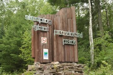
Sleeping Giant Provincial Park

Park Size: 24,751 hectares
Park Amenities:
Sleeping Giant Provincial Park is a popular recreation and campground destination located on the shores of Lake Superior - east of the community of Thunder Bay, Ontario, Canada. Thunder Bay is part of the North of Superior region of Northern Ontario, Canada.
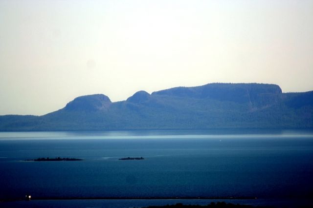
The park is a collection of rock cliffs and islands forming a silhouette of a man on the southern end of the Sibley Peninsula. According to First Nation legend the image of the man is said to be Nanabosho - the son of the West Wind - who was frozen in stone by the Great Spirit of the Ojibway people.
Today, the Sleeping Giant Provincial Park is a popular year round land and water recreation destination. In fact the Sleeping Giant rock formation is the western boundary to the Lake Superior National Marine Conservation Area (L.S.N.M.C.A.).
The activities enjoyed in the park include hiking, sightseeing, birdwatching, picnicking, mountain biking, kayaking, canoeing, swimming, fishing, camping, backpacking & wilderness camping. During the winter months xc skiing is very popular in the park.
The campground includes non serviced and serviced campsites. Other services include laundromat, showers, washrooms, sani station, power, recycling, firewood and ice. There is an information centre with a day use picnic area, washrooms, playground and currency exchange.
Some of the other services available in the park include canoe and kayak rentals, rod and reel fishing rentals, conference facilities, gift store, cottages, educational programs and tours. The information centre provides detailed maps of the park and trails.
There are many day use picnic sites in the Sleeping Giant Provincial Park. The popular picnic sites include the Pounsford Lake, Lizard Lake, Marie Louise Lake and Rita Lake Picnic Areas.
The Sleeping Giant Park provides many easy-going nature walking trails and over 80+ kilometres of wilderness recreation trails. There are trails for all fitness levels and age groups.
Here is a list of some of the more popular trails in the park :
Walking Nature Trails
Joe Creek Trail : An easy going 1.6 km (1 mi.) loop trail which follows the banks of the creek visiting with some mini waterfalls.
Thunder Bay Bogs Trail : An easy-going 0.8 km (0.5 mi.) loop trail which explores a rocky, forested terrain prior to connecting with a small lake.
Piney Wood Hills Trail : A moderately easy 1.5 km (0.9 mi.) one-way trail which navigates through a forest of trees prior to connecting to a lookout area over looking Joeboy Lake.
Sibley Creek Trail : An easy-going 1.7 km (1 mi.) trail which explores a forest of trees eventually connecting to Sibley Creek and a marsh environment. Popular for beaver dam and waterfowl sightings.
Plantain Lane Trail : An easy-going 0.5 km (0.3 mi.) one-way trail leads to a small bridge over Sibley Creek. The bridge is a good area for views of the creek environment.
Ravine Lake Trail : An moderately easy 1.5 km (0.9 mi.) loop trail leading to lookouts over Grassy Lake before descending down to the shores of Ravine Lake. The trail connecting the lakes is steep and can be slippery and challenging for some.
Hiking & Backpacking Trails
Kabeyun Trail : A challenging one-way 40 km (25 mi.) loop trail which follows the west and east shoreline of the Sleeping Giant. The west side of the trail begins near the Thunder Bay Bogs Trail. From the trailhead the trail explores south and visits with the Thunder Bay Lookout, Clavet Point, Hoorigan Point & Sawyer Bay. The east side of the trail visits Lehtinen's Point, Tee Harbour and eventually hooks up with the trailhead entrance on Highway #587. The trail is very scenic and visits with many sandy beaches and private bays.
Burma Trail : A moderately challenging one-way 11.5 km (7 mi.) trail which explores a forest of red and white pine trees and visits with a number of smaller lakes including Norwegian Lake. The trail includes sections of hiking navigating over some challenging rocky terrain.
Sifting Lake Trail : A moderately easy one-way 2 km (1.2 mi.) trail which explores under the cover of trees before connecting with Sifting Lake.
Twinpine Lake Trail : A one-way trail measuring 4.5 km (2.7 mi.) which connects the Kabeyun Trail with the Burma Trail. Along the way you visit with Twinpine Lake.
Pickerel Lake Trail : A 10 km (6.2 mi.) trail system which is very popular for xc skiing during the winter months. The trail explores a white pine forest and visits with lakes like Pickerel and Rita Lakes.
Sawyer Bay Trail : A moderately challenging 6.0 km (3.7 mi.) one-way trail which is more like a deactivated road which leads to the foot of the peninsula and Sawyer Bay.
Middleburn Trail : An easy-going, one-way 4.2 km (2.6 mi.) trail which connects to a secluded sandy beach and a wetland marsh area ideal for birdwatching. At the beach one can pick up the trail again and continue to Finlay Bay.
Talus Lake Trail : A moderately challenging 5.0 km (3.1 mi.) one-way trail which explores between two mountains (Sleeping Giant and Thunder Mtns) while visiting with a waterfall, remote lakes, rocky cliffs and a talus slope.
Top of the Giant Trail : A challenging 22.4 km (14 mi.) return hike starting from the trailhead on the Kabeyun Trail to the top of the Sleeping Giant. The trail is considered difficult with many sections of hiking steep elevations and switchbacks. The summit provides jaw dropping views of the region.
Biking is only permitted on the Sawyer Bay Trail, Sawbill Lake Trail, Burma Trail, Pickerel Lake Trail, Thunder bay lookout Road and Marie Louise Drive.
Explore Sleeping Giant Provincial Park, Thunder Bay, Ontario, North of Superior, Canada
Address: