Roberts Creek Mountain Bike Loop Trail

Roberts Creek
Trail Length: 30 km
Difficulty: Difficult
Park Amenities:
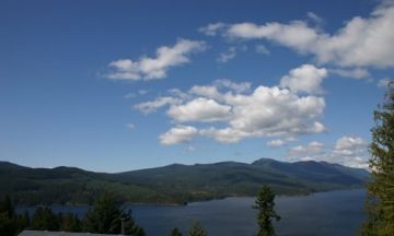
Roberts Creek Mountain Bike Loop Trail is located in the Roberts Creek, BC area on the lower Sunshine Coast north of Gibsons B.C., south of Sechelt, British Columbia, Canada. The bike route is an advanced mountain bike adventure that covers 30 km (18 mi.) with some steep climbs, forest trails, logging roads and... much... downhill speed. The total Roberts Creek Bike Loop Trail should take about 2-3 hours to complete. That is taking into considering that there are no breaks taken to relax and take in some nature with views of the Tetrahedron Mountain Range & Georgia Strait.
The Roberts Creek Bike Loop Trail route experiences an 800 m (ft.) elevation gain. The route is identified by white biking signs and double rings of orange paint. Follow the main Roberts Creek Forestry Service Road for 4.5 km (2.7 mi.) past first junction (stay left, if so desired for 1 km to a viewpoint and then double back). Continue the adventure for another 4 km (2.4 mi.) and turn left at the junction. A right takes you on the Dakota Creek Loop Trail. Stay left for another 13 km (8 mi.) until Field Road and then take a left back to the Roberts Creek Forestry Service Road.
The Roberts Creek Bike Loop Trail crosses over Clack Creek, Gough Creek, Flume Creek and Wilson Creek. Plan the route accordingly as many of the off shoot trail routes will connect you to other bike routes leading you far away from your vehicle. This Roberts Creek Bike Loop Trail connects you to the Mount Elphinstone, Dakota Creek and the Brodie Trail loops.
Roberts Creek Mountain Bike Loop Trail, Roberts Creek, BC on the Sunshine Coast.
Address:
Roberts Creek Mountain Bike Loop Trail
Roberts Creek Forestry Service
Roberts Creek
Canada
How To Get ToRoberts Creek Mountain Bike Loop Trail
:How to Get Here: Follow Hwy 101 north from Gibsons, BC for 10 km (6 mi.) or drive south on Hwy 101 from Sechelt BC to Roberts Creek. Approaching from Gibsons take a right on to Roberts Creek Forestry Service Road. If you past the Cliff Gilker Park you have driven 500 m (1640 ft.) too far. Go back and find the Roberts Creek Forestry Service Road. Travel the road for 1 km (0.6 mi.) to the power-lines and then park and go.

No reviews yet for Roberts Creek Mountain Bike Loop Trail.
