Christina Crest Trail

Trail Length: 20 kilometres
Difficulty: Difficult
Park Amenities:
Christina Crest Trail is a 20 kilometre one-way mountain biking, hiking, backpacking and horseback riding route exploring the vast wilderness landscape, in and around, the Santa Rosa Summit on the Cascade Highway located west of the community of Rossland in the Kootenay region of British Columbia, Canada. After the snow has fallen the trail becomes a cross country ski and snowshoe route for the most adventurous during the winter months.
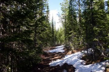
The Christina Crest Trail explores, mostly, through an alpine forest. At some point along the trail one breaks though the treeline and begins exploring wide open mountain meadows providing great views of alpine meadows, mountain peaks, rock cliffs and far reaching views.
The Christina Crest Trail is a single track trail which, by many, is considered a moderate to difficult recreation route with a total elevation gain of 550 metres (1850 feet). The trail follows a mountain ridge, much of the way, leading to Mount St. Thomas which stands at 2038 metres. Once you are close to Mt. St. Thomas the recreation trail comes to a fork in the trail with three options. Follow the trail leading to the right leads all explorers down into a valley and the Bonanza Creek parking lot and trailhead. The trail on the left is the Vertical Smile Trail. The trail down the middle leads to the summit of Mt. Saint Thomas.
The Christina Crest Trail is best enjoyed in 2-3 days when hiking the trail. Mountain bikers and horseback riders can complete the trail in one day - a long day. The trail is a self maintained route meaning leave no trace - no foot print - pack out what you pack in. This is beautiful country, a home to wildlife and we should treat it with respect.
Hiking or riding south to north is the preferred route. Located east of the south trailhead on the Cascade Highway is a no frills wilderness recreation campsite for overnight camping called the Santa Rosa Creek Campsite. Since it is a one way trail some camp overnight and start at the south trailhead and then park a car on the north end of the trail at the Bonanza Creek parking lot and trailhead.
Christina Crest Trail, Rossland, British Columbia, Canada
Address:
How To Get ToChristina Crest Trail
: